
What is Geotagging? Your Guide to Photo Location Data
Ever wonder how your phone knows exactly where you took that stunning sunset photo? Or how a social media platform can suggest a location tag for your latest post? The magic behind this is geotagging, the fascinating technology that embeds location information directly into your images. This guide will demystify geotagging, exploring what it is, how it works, its benefits, and crucial privacy considerations. If you've ever asked, How to find the location of a photo?, you're about to discover the complete answer, from hidden data to cutting-edge AI.
What is Geotagging? Defining Photo Location Data
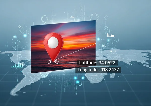
At its core, geotagging is the process of adding geographical identification metadata to various media, such as a photograph or video. This data usually consists of latitude and longitude coordinates, though it can also include altitude, bearing, distance, and even place names. Think of it as a digital fingerprint that links your photo to a specific point on the planet. This information is stored within the image file itself, typically as part of its EXIF (Exchangeable Image File Format) data.
This means that long after you've left a location, the photo itself retains the "memory" of where it was born. For casual memory keepers, this is an incredible way to organize albums. For photographers and travelers, it’s an indispensable tool for cataloging shoots and retracing steps.
The Core Components of Geotagged Photos
The heart of geotagged photos lies in its specific data points. The most fundamental components are latitude and longitude, which pinpoint the exact spot on Earth with remarkable accuracy. But modern devices often add more layers of context. This can include altitude, showing how high up you were—perfect for hiking or drone shots—and the direction the camera was facing. This rich collection of metadata transforms a simple picture into a detailed record of a moment in time and space.
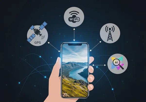
Not Just GPS: Understanding Diverse Location Sources
While the Global Positioning System (GPS) is the most well-known source for geotagging, it's not the only one. Many devices use a hybrid approach to determine your location. If a GPS signal is weak or unavailable (like indoors), your smartphone can triangulate its position using cellular network towers or nearby Wi-Fi hotspots. This ensures that even without a clear view of the sky, your photos can still receive reasonably accurate location information, creating a more complete and reliable digital scrapbook of your adventures.
How Photo Location Data Works: The Technology Behind Geotagging
Understanding how photo location data works reveals a seamless integration of hardware and software. When you snap a picture with a GPS-enabled device, its internal receiver communicates with satellites to generate precise coordinates embedded into your photo's metadata. This automatic process is incredibly convenient. But what if a photo has no GPS data, perhaps from an older camera or with location services off? This is where advanced methods, moving beyond metadata reading to intelligent analysis, come into play. For anyone looking to uncover a photo’s origin, a powerful photo location finder can make all the difference.
GPS Integration: Pinpointing Exact Coordinates
The primary technology is GPS integration. A device's GPS chip receives signals from at least four satellites to calculate its precise location via trilateration. It measures signal travel time to determine latitude, longitude, and altitude. This system is highly accurate, often within a few meters, making it the gold standard for geotagging new photos.
Cell Towers & Wi-Fi: Bridging the Location Gaps
When GPS is unavailable, your device uses other signals. It can estimate a location by identifying nearby cell towers and measuring signal strength. Similarly, it scans for known Wi-Fi networks, referencing large databases that map hotspot locations. By recognizing nearby networks, your phone can infer its location with surprising accuracy. This hybrid approach captures location data in more environments.
AI Visual Analysis: Finding Location Without Metadata
This is where the real magic happens for photos without geotags. What if you could find a location just by analyzing the image's pixels? That’s the power of AI visual analysis. Advanced AI-powered tools use sophisticated algorithms to analyze the photo's content. The AI identifies unique landmarks, architectural styles, vegetation, and even text on signs (using Optical Character Recognition). It then cross-references these visual clues against a massive database of global imagery to determine the most probable location. This groundbreaking technology means even old, scanned, or saved social media photos can reveal their secrets. It’s the ultimate solution when EXIF data is missing. You can analyze your photo to see it in action.
Why Geotag Your Photos? Benefits & Practical Uses
Understanding the "why" behind geotagging photos reveals its immense value across different use cases. From personal organization to professional workflows, location data enriches our images and unlocks new possibilities. It transforms a static gallery into an interactive map of your life's journey, making memories more vivid and accessible. For content creators and professionals, it provides an essential layer of context and data that can streamline their work and enhance their storytelling.
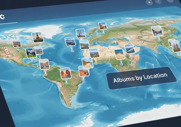
Effortless Organization & Memory Preservation
For the casual user, the primary benefit is effortless organization. Photo management apps can automatically sort your pictures by location, creating albums for "Vacation in Paris" or "Weekend in the Mountains." This makes it incredibly easy to find specific memories without sifting through thousands of files. When you look back at an old photo and wonder, "Where was this taken?", the answer is right there, preserving the context of the moment forever.
Enhancing Storytelling & Travel Planning
Travel bloggers and content creators can leverage geotags to craft more immersive stories. By plotting their photos on a map, they can create interactive travelogues that guide their audience through their journey. Furthermore, if you discover an inspiring photo online without a location tag, you can use a tool like our AI tool to find that hidden gem. This ability to reverse-engineer a location from a picture is invaluable for planning future trips and discovering unique photo spots off the beaten path.
Professional & Investigative Applications
Beyond personal use, geotagging has serious professional applications. Journalists use it to verify the location of images from sources, adding credibility to their reports. In fields like insurance and real estate, geotagged photos provide indisputable proof of a property's condition at a specific location and time. Environmental scientists use it to track changes in landscapes, while emergency services can use geotagged images from the public to assess a situation on the ground.
Geotagging & Privacy: Risks and How to Manage Your Location Data
While geotagging has incredible benefits, be aware of the privacy implications. Sharing a geotagged photo also shares your whereabouts, potentially revealing sensitive locations like your home, workplace, or children's school. Understanding these risks and managing your data is crucial for using geotagging safely. Fortunately, you have complete control over your photo location data. iOS and Android offer simple controls to manage location services for your camera app. By being mindful of what you share and using available privacy settings, you can protect your personal information.
Potential Privacy Concerns: What You Should Know
The primary risk is unintentional oversharing. Posting a geotagged photo from your home can broadcast your address to the world. A series of geotagged vacation photos posted in real-time can signal that your home is empty. It's important to consider the audience and platform before sharing a photo with its location data intact. Awareness is the first step toward mitigating these potential privacy concerns.
How to Control and Remove Photo Location
You can easily manage your settings to remove photo location data. On most smartphones, you can turn off location access for your camera app entirely. You can also use various apps and software to strip EXIF data from photos before you share them online. Many social media platforms automatically remove this metadata upon upload to protect user privacy, but it’s always wise to be proactive and control what information you send out in the first place. For photos you receive, you can always check photo metadata to see what information they contain.

Unlock Your Photo's Story: The Power of Location Data
Geotagging has fundamentally changed how we interact with our photos, transforming them from simple images into rich data points full of stories. It allows us to organize our memories, discover new places, and add a powerful layer of context to our visual narratives. From the precision of GPS to the intelligence of AI visual analysis, the technology for understanding photo location has never been more accessible.
Whether you're a casual memory keeper looking to sort your family albums, a photographer cataloging your work, or a traveler hunting for your next destination, understanding and utilizing location data is key. Ready to uncover the story behind your own pictures? Visit our homepage and upload a photo to see what you can discover.
Frequently Asked Questions About Geotagging
How to find the location of a photo?
The easiest way is to check the photo's EXIF data, which may contain GPS coordinates. If that data is missing, you can use an advanced online tool. Platforms leveraging AI analyze visual cues in the photo itself to identify the location, making it possible to discover the location even without metadata.
How does a photo get its location if there's no GPS?
Beyond GPS, a photo's location can be determined by triangulating signals from nearby cell towers or known Wi-Fi hotspots. More impressively, AI-powered tools can find a location by recognizing landmarks, architecture, and other visual clues within the image, comparing them against a global database to pinpoint the spot.
Can I remove location data from my photos?
Yes, absolutely. You can turn off location services for your camera app on your smartphone to prevent geotagging in the first place. For existing photos, numerous apps and online tools can strip the EXIF data, including the location, before you share them.
What's the difference between EXIF data and geotagging?
EXIF data is the broad container for all metadata in an image file, including camera settings (aperture, shutter speed, ISO), date, time, and camera model. Geotagging refers specifically to the location-based information (latitude, longitude, altitude) that is stored within that larger EXIF dataset. In short, geotagging is a type of EXIF data.